


- Home
- About Us
- Sailing Courses
- Powerboat Courses
- SLC - International License
- Yacht Vacations
- Find an On-Water Instructor
- Practical Courses
- Fighting Childhood Cancer
- Free Courses Signup
- Student Benefits
- Gift a Sailing Course
- Sailing Opportunities
- Sailing Licenses and Certifications
- About the Sailing Certifications
- Sailing Blog & Helpful Articles
- NauticEd Podcast Series
- Yacht Charter Resources
- School Signup
- Instructor Signup
- Affiliate Signup
- Boat Sharing Software
- Sailing Industry Services
- Support & Contact
- Newsroom
- Privacy Policy
Coastal Navigation | Online Course


Coastal Navigation, Made Practical
Preparing for coastal passages or your next bareboat charter? This online coastal navigation course gives sailors and powerboaters the crucial knowledge and skills to safely plan and navigate coastal boating adventures. You’ll learn how to read and interpret nautical charts, plot accurate courses, fix your position (DR, 3-bearing, running fix), convert between true/magnetic/compass, and calculate tides and currents (set & drift) for dependable passage planning.
✓ Designed for sailors and powerboaters—HIGHLY recommended for coastal cruising and bareboat charters
✓ An online course that provides essential skills to plan passages, read charts, and navigate safely—includes real-world tips and drills for practical navigation
✓ Includes a printable practice chart. A full-size chart and plotting tools are available for purchase separately
✓ Recognition on your free online boating resume upon successful completion
✓ Lifetime access, including free updates online or in the NauticEd App
✓ 30-day Money Back Guarantee
Estimated Time: 10 hours
Price: $39 (or $33 with the Bareboat Charter Master Sailboat Bundle or Bareboat Charter Master Powerboat Bundle)
Bonus: All NauticEd students receive the free Nav Rules courses, free eLogbook and Boating Resume, and special discounts from our industry partners. What's Included >
What Students Say
✨AI generated from student reviewsStudents call Coastal Navigation “thorough, demanding, and worth it.” Many note it’s the toughest NauticEd module they’ve taken—but also the one that most boosted real competence. Expect ~10 hours of self-paced work with lots of reps: paper plotting, DR, three-bearing and running fixes, TVMDC conversions, and set & drift. Reviewers praise the clear visuals, well-structured examples, and detailed solution keys that make mistakes teachable. Several say it exposed how electronics-dependent they’d become and rebuilt true chart-work confidence. Support gets high marks—students mention helpful responses by phone and from the instructor team. Overall sentiment: challenging, professional, and comprehensive; a course people return to as a reference—and one many say left them calmer and more capable in unfamiliar waters.
Why Take Coastal Navigation?
Whether you’re at the helm of a sailboat or powerboat, safe coastal cruising depends on much more than GPS. GPS can be inaccurate, electronics can fail, charts can be confusing, and coastal waters are full of hazards. The Coastal Navigation Course gives you the skills to independently plan and execute passages, make smart decisions when conditions change, and navigate accurately in and out of harbors, channels, and unfamiliar coastlines.
- Essential Knowledge and Skills: Understanding charts, identifying hazards, and planning coastal cruises are all critical skills regardless of whether you use paper charts or GPS chart plotters.
- Confidence to Explore More: Extend your cruising grounds beyond “line-of-sight” day trips with the confidence that you can handle real-world navigation challenges.
- Backup to Technology: GPS is powerful, but knowing how to read charts, bearings, tides, and currents ensures you’re never lost if the GPS is inaccurate or the electronics go down.
- Safer, Smarter Boating: Learn to avoid hazards, time your passages, and interpret navigation aids correctly so you keep your crew and vessel safe.
- Needed for Charters: Most charter companies and licensing authorities expect proof of navigation competence before handing over the keys to a charter boat.
This Course is Perfect for You If:
- You're a sailor or powerboater who wants to extend your cruising grounds beyond line-of-sight day trips to real coastal cruising and adventures.
- You're planning to bareboat charter and want to add coastal navigation to your boating resume—as well as charter confidently!
- You're an aspiring skipper who wants to build competence and readiness for coastal cruising or bareboat charter certification and licensing.
- You're an experienced cruiser who wants a reliable backup to GPS and the know-how to handle tickets, currents, and coastal hazards.
We guarantee both your satisfaction AND Lifetime access to any boating course you buy from us.
What You'll Learn in Coastal Navigation
You’ll learn how to confidently plan and execute coastal passages using real-world navigation skills. This includes reading and interpreting nautical charts, plotting courses, fixing your position with DR and bearings, converting between true, magnetic, and compass headings, and calculating tides and currents to predict set and drift. These skills give you the confidence and safety margin to explore further, whether chartering abroad, cruising new coastlines, or preparing for recognized certifications and licenses.
View the Course Topics
Chartwork Fundamentals
- How to read a nautical chart and interpret nautical chart symbols
- Aids to Navigation (IALA buoyage) and lights
- Latitude & longitude, units, surface geometry, scale
- Chart familiarization and setup
- Navigation tools: dividers, plotter/parallel rulers/protractor (“slide rule”)
- Dead reckoning and standard navigator symbols
- Lines of position; three-bearing fix; running fix; triangulation
- Variation & deviation; true ↔ magnetic ↔ compass conversions
- Distance–speed–time math and reliable ETA calculations
- Using GPS positions with paper plots
- Collision-avoidance implications of your fixes
- Understanding and predicting tides (primary & subordinate stations)
- Understanding and predicting current
- Leeway and set & drift (rate & direction)—known/unknown cases
- Correcting headings and refining ETAs
- Passage planning: considerations, timing windows, hazards—worked example
- Practical plotting drills to build speed and accuracy
Everything You Get with This Course
- The Coastal Navigation online course teaches navigation knowledge and skills for inland and near-coastal sailing and powerboating
- Available immediately online: start learning today at your own pace.
- Duration: Approximately 10 hours
- Unlimited Access: Lifetime access lets you review course materials anytime. Course updates are free.
- Includes a printable practice chart: A full-size chart and plotting tools are available for purchase separately (read below for more details).
- Recognition: Upon successful completion, you receive immediate recognition on your boating resume that verifies for charter and insurance companies that you've completed the course.
- Qualification: Serves as a required course for both sail and powerboat Bareboat Charter Master certification and international SLC licensing.
- Convenient Formats: Take the course on your desktop or laptop—and tablet or mobile phone using the free NauticEd App.
- View an excerpt from the Coastal Navigation Course
Price Today: $39 (or $33 with the Bareboat Charter Master Sailboat Bundle or Bareboat Charter Master Powerboat Bundle)
Hands-on requirements:
Note that while this is primarily an online course, you'll need a Long Island Sound chart and your own plotting tools to practice working with actual physical charts. Full sourcing details and links are provided inside the course.
- Chart: NOAA 12354 – Long Island Sound. Buy a printed copy (≈$15) or download the free PDF and print locally.
- Plotting tools: Use your own set (dividers + rotating protractor/plotter or parallel rulers). Or pick up a nav pack (≈$39 on Amazon) that includes the chart, a rotating protractor-plotter, and compass dividers.
Recommended Companion Course:
Pair this with the Electronic Navigation Course to apply coastal navigation fundamentals to modern instruments, chartplotters, and apps.
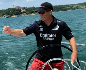
Foreword by Captain Grant Headifen
Enough years ago, so that this story can be attributed to youth rather than present-day embarrassment, we set off from St. Bart's in the Caribbean to St. Eustatius. While most islands in the Caribbean can be navigated by a line of sight, with this passage, St Eustatius is over the horizon so proper navigation techniques were required.
Read the Foreword
This was my first Chartering experience and as Captain, I was responsible for 6 crewmembers' lives and, of course, the vessel. A quick check of the charts revealed that St Eustatius was slightly west of a due south heading and was about 25 miles away - at 6 knots that would take us about 4 and a bit hours. Simple enough. Up anchor and hoist sails. Yet three times in 1/2 an hour increments something inside me was questioning my rudimentary assessment of the navigation ease. Finally, on the third visit to the charts, I spotted the compass rose and thus the source of my anxiety. At that position on the planet, the difference between the chart's definition of north and the compass reading of north is different by nearly 15 degrees.
 Whoops! A simple but amateurish mistake. Time to get serious. Now more skillful techniques had to be called upon. A new and real position had to be calculated based on the 1.5 hours of incorrect heading and the average maintained speed. Then a new plot direction had to be established for St. Eustatius based on our newly determined position. To double confirm that newly determined position I triangulated our position by taking compass shots off various islands. Back on track, we thoroughly enjoyed the rest of our vacation with a lesson never to be forgotten!
Such amateurish mistakes can lead to serious consequences. What if there had been a reef on our mistaken course? Get the picture?
Captain Ed Mapes' Coastal Navigation Course, as you'll discover, is one of those "oh durh could have had a V8" moments because of his reduction of the seemingly intimidating world of marine navigation to an exciting understanding and confidence in your knowledge to now - Navigate. He has turned intimidation to inclination. Inclination to get out and really practice and use your new skills.
You'll leave this Coastal Navigation Course with an understanding of:
- The Charts and how to use navigation tools
- True north and magnetic north - and variation and deviation
- Determining your position using various techniques such as dead reckoning, running fixes, and triangulation
- What to do with your GPS position to get you to your destination
- Set and drift from wind, tides, and currents
- How to simply determine your heading based on Set and Drift
You'll then run through real exercises to build your confidence. In the first Module, we'll introduce you to Landfall Navigation where you can mail order globally ($10 +S&H) a practice chart for the confidence-building exercises and the test. The test grades are in real-time - so that once you've passed - you'll have your Navigation Certification in hand immediately.
Register for the NauticEd Coastal Navigation Course now and as an incredibly FUN BONUS, we'll give you a GPS treasure hunt formula that you can use to set up in your neighborhood park for an enjoyable family and friends navigation picnic. Remember, with NauticEd, you can return as many times as you like to brush up on your navigation skills for FREE.
There are possibly only a few things more fun than scooting along the ocean taking compass sights off islands using dead reckoning and running fix skills to determine your position and then calculating your ETA. One of those things is actually meeting your ETA, then celebrating with a cold drink and your feet in the sand.
Please enjoy Captain Ed Mapes' Coastal Navigation Course. As with all NauticEd online sailing and powerboating lessons, if you don't feel as though you received the value for this Coastal Navigation course, then we'll simply refund your $39 investment back to you. With thousands of happy NauticEd students, however, we doubt that will happen.
If you still have questions about the courses and/or the sailing certifications, please contact us and we're happy to help.
About NauticEd
NauticEd is the leading provider of modern sailing education, combining online sailing courses with accredited on-water instruction. With over 300,000 students worldwide, NauticEd is the only U.S. sailing body recognized for meeting U.S. Coast Guard and NASBLA standards under the American National Standards for boating education.
Our online courses pair with on-water training, and your free eLogbook and sailing resume track each milestone. Whether you’re starting out or working toward higher endorsements, NauticEd gives you a clear, standards-aligned way to grow real skills.
Course Authors

By Ed Mapes
USCG Captain Master Mariner
By Grant Headifen
NauticEd Global Director of Education
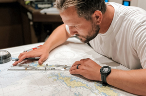
Photo Credit: Capt. Josh Rundle
Josh Rundle Sailing Education in Annapolis MD
View Coastal Navigation Course excerpt
Student Reviews
Glenn W.
2026, 22 Jun. 18:00
Refamiliarized with set and drift.
Kyle H.
2026, 10 Jun. 15:42
Great all around!
Shelby R.
2026, 09 Jun. 01:51
Challenging but thorough and very helpful.
John R.
2026, 08 Jun. 16:47
Comprehensive and occasionally challenging.
Mark B.
2026, 02 Jun. 05:30
Rigorous!
Bruce O.
2026, 16 May. 16:50
Real practical work
Sanjay P.
2026, 15 May. 05:18
Good content
Shannon C.
2026, 05 May. 18:25
I liked that I finally finished the damn thing. It was quite confusing for a while.
Joseph L.
2026, 25 Apr. 20:48
Overall, it’s a great self-pace course! From the reading material to the videos are icing on the cake to ensure the visual aspect of learning. I will definitely recommend NauticEd to others as the TOP Sailing Education Platform for learning how to sail with confidence.
Edward J.
2026, 11 Apr. 19:09
Very comprehensive and a terrific learning tool
Terry R.
2026, 07 Apr. 03:33
I love working with charts.
George G.
2026, 02 Apr. 17:23
showed the recreational boater the more accurate way.
List Price: $39.00
Excerpt from the course
Expand Excerpt from the courseQuestion:-
You are sailing along on a heading of 57° psc (61° Mag) (47° T), and your knot meter reads 5 knots. You are passing Horton Point Light to your starboard. At 1548, a handheld bearing shows that the bearing to Horton Point Light is 119°Mag (105°T). You decide to do a running fix. At 1615, the bearing to Horton Point Light is 160°M (146°T). Determine your running fix position.
Solution:
Watch the animation then read the text then watch the animation again.
The time elapsed is
1615 minus 1548
Or
1575 -1548 = 27 minutes (/60) = .45 hours
At 5 knots you will travel 5 x 0.45 = 2.25 NM
You draw the true bearing line of 105° T to Horton Point Light. You then draw a vector 2.25NM long in the direction of your heading 47° T starting anywhere on the 105° line. You then draw another line parallel to the first 105° T bearing that intersects the endpoint of the 2.25NM vector. Finally, you draw in your second bearing line of 146° T. Where the 146° T line intersects the parallel 105° T line - you mark it as your running fix position.
The theory behind this is simple but not usually explained. Initially, you must lie on the 105-degree line somewhere but you don't know where. You know that over the time elapsed, you will travel the 2.25 NM from somewhere off the initial 105-degree line but you don't know where - yet. The parallel 105-degree line projected forward means that you will also lie somewhere on that projected line - again -somewhere. By doing the second bearing - off any object - the intersection of that bearing with the projected line means you must be at that point (given that your speed and heading were accurate).
Answer - LAT 41° 06.1' N and LONG 72° 27.0'W
Trusted by the world's leading sailing companies
From our students
4.9 out of 5 average across 74,411 student course ratings.
-
"I liked that there wasn’t pressure to rush. I could actually understand what I knew and what I still needed to work on."
Jamie, first-time boater
-
"By the time we chartered, I felt prepared instead of just approved. That made all the difference."
Alex, preparing for bareboat charter
-
"NauticEd helped me see boating as a skill I could build, not something I had to pass or fail."
Morgan, new boat owner