


- Home
- About Us
- Sailing Courses
- Powerboat Courses
- SLC - International License
- Yacht Vacations
- Find an On-Water Instructor
- Practical Courses
- Fighting Childhood Cancer
- Free Courses Signup
- Student Benefits
- Gift a Sailing Course
- Sailing Opportunities
- Sailing Licenses and Certifications
- About the Sailing Certifications
- Sailing Blog & Helpful Articles
- NauticEd Podcast Series
- Yacht Charter Resources
- School Signup
- Instructor Signup
- Affiliate Signup
- Boat Sharing Software
- Sailing Industry Services
- Support & Contact
- Newsroom
- Privacy Policy
Electronic Navigation | Online Course
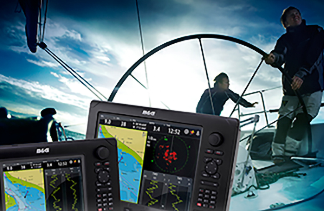

Navigate with Modern Technology
Are you planning a sail or powerboat coastal cruise, bareboat charter, or the challenge of boating in bad weather? The Electronic Navigation course teaches you more than button-pushing skills—it teaches you how to operate modern marine GPS systems, GPS chartplotters, AIS, radar, and weather electronics with clarity and confidence. By the end, you’ll move beyond “hoping the tech works” to making calm, precise, and well-timed decisions at sea, day or night, sail or power.
✓ Designed for sailors and powerboaters
✓ Learn how to set up your systems, plan passages with real-world forecasts and currents, use radar and AIS to identify risks early, and run disciplined routines (MOB, autopilot, etc…)
✓ Recognition on your free NauticEd sailing resume
✓ Lifetime access, including free updates online or in the NauticEd App
✓ 30-day Money Back Guarantee
Estimated Time: 5 hours
Price: $29 $25 (or $19 with the Bareboat Charter Master Sailboat Bundle or the Bareboat Charter Master Powerboat Bundle)
Bonus: All NauticEd sailing students receive the free Navigation Rules course, free eLogbook and Boating Resume, and special discounts from our industry partners. What's Included >
What Students Say
✨AI generated from student reviewsLearners consistently call this course “confidence-building” and “thorough,” with many praising the clear animations and the interactive chartplotter drills that make complex settings—COG/SOG, depth offsets, AIS, radar/MARPA, alarms—click fast. Even experienced skippers and former merchant captains say they discovered features their manuals never explained and immediately applied them to real trip-planning (e.g., Navionics pre-plans). Reviews highlight the no-fluff focus on practical workflows, helpful explanations for missed test questions, and a balanced mix of fundamentals and advanced topics (VMG/VMC, polars), noting the exam is “a bit tough” in a good way. Several call it a great refresher before charters, with “hidden tricks” that improve how they use their existing gear. The consensus: polished instruction, useful simulators, and tangible gains in judgment at the helm.
Why Take Electronic Navigation?
In the modern age of marine electronics, simply owning GPS or chartplotter isn’t enough — like any tool, you must become proficient with its setup, features, and use to reduce navigational and weather risks while making the most out of your time on the water. Improving your electronic navigation knowledge skills brings real advantages:
- Greater safety and fewer accidents: Studies show that the use of electronic navigational charts (ENCs) and modern digital navigation tools reduces collisions and groundings.
- Smarter decision-making under pressure: Integrated systems (radar + AIS + charts + weather) let you see risk before it arrives, reducing the burden on your judgment.
- Better operational efficiency and precision: Better route planning, real-time adjustments, and effective workflow mean you waste less time, fuel, and mental energy.
- From gadget user to confident skipper: You’ll advance from “hoping my electronics help me” to “my electronics are part of my seamanship toolkit”.
This Course is Perfect for You If:
- You’re a powerboater or sailor preparing for coastal cruising or challenging weather.
- You’re planning a bareboat charter and want to handle unfamiliar waters with confidence.
- You’re a yacht owner looking to integrate radar, AIS, and chartplotters into safe routines.
- You’re a serious crew member ready to step up as a competent navigator.
Your enrollment includes lifetime course access, recognition on your free NauticEd sailing resume, and a complete satisfaction guarantee.
What You'll Learn in Electronic Navigation
NauticEd’s Electronic Navigation online course teaches you how to operate modern boat electronics as one dependable system. You’ll calibrate and interpret depth and speed, separate heading from COG and log from SOG, place accurate waypoints, and shape routes that hold tight cross-track limits. Then you’ll integrate the full picture with AIS, radar (MARPA with CPA/TCPA), electronic charts, GRIB weather, tides/currents, and autopilot coupling. Interactive chartplotter drills mirror real helm workflows so decisions are faster for sail or power.
View the Course Topics
Electronic Navigation Fundamentals (GPS, Chartplotters & Electronic Charts)
- Depth & depth offset
- How a GPS works
- Heading vs. Course Over Ground (COG)
- Boat speed (log) vs. Speed Over Ground (SOG)
- Waypoints that matter
- Apparent wind
- True wind
- True wind direction
- Angles vs. directions
- The wind triangle
- Advanced wind calculations
- Measuring the wind
- Wind shear and related effects
- Tacking angle
- Current effects
- COG and true wind
- Next-leg wind angle
- Velocity concepts
- Velocity Made Good on Course (VMC)
- Velocity Made Good (VMG)
- Polar plots
- VMG performance
- Polar speed & performance use
- Waypoints and destinations
- Course line
- Route points
- Course to Steer (CTS)
- Laylines
- Track and COG
- Cross-Track Error (XTE)
- AIS (targeting, CPA/TCPA awareness)
- Radar (including MARPA/ARPA)
- Weather planning
- Using GRIB files
- Offshore internet communication via Starlink
- Button logic & page groups
- Screen dim & night mode
- Man Overboard (MOB) workflow
- Using the cursor
- Zoom controls
- Adding waypoints
- Panel menus & settings menu
- Units
- Depth offset
- Instrument bar
- XTE display & management
- Tides, currents, moon data
- Alarms (depth, arrival, anchor, XTE)
- Routes (create, edit, follow)
- Weather GRIB layers
- Autopilot coupling
- Radar overlay
- Vessel targeting
Everything You Get with this Course
- The Electronic Navigation online course teaches you how to us GPS, chartplotters, radar, AIS, Navigation and Weather Mobile Apps, and weather data.
- Available immediately online: start learning today at your own pace.
- Duration: Approximately 5 hours
- Unlimited Access: Lifetime access lets you review course materials anytime. Course updates are free.
- Compatibility: Works with most helm setups—Garmin, Raymarine, B&G/Simrad—and tablet apps.
- Hands-on practice: A lifelike plotter sim walks you through units and depth offsets, waypoints and routes, XTE, AIS and radar, GRIB weather, tides/currents, alarms, autopilot, and MOB.
- Recognition: Upon successful completion, you receive immediate recognition on your sailing resume that verifies for charter and insurance companies that you've completed the course.
- Qualification: Serves as a required course for both sail and powerboat Bareboat Charter Master certification and international SLC licensing.
- Free Stuff: All NauticEd students receive the free Navigation Rules course, a free eLogbook and Boating Resume, and special discounts from our industry partners.
- Convenient Formats: Take the course on your desktop or laptop—and tablet or mobile phone using the free NauticEd App. A downloadable PDF is available for offline use.
- View Electronic Navigation Course excerpts
Price Today: $29 $25 (or $19 with the Bareboat Charter Master Sailboat Bundle or Bareboat Charter Master Powerboat Bundle)
Next Steps
- Enroll in Electronic Navigation and learn marine GPS, chartplotters, AIS/radar, GRIBs, and alarms.
- Set up your electronics. Before your first practice run, confirm units, depth offset, safety depth shading, and key alarms (depth, arrival, XTE).
- Practice with the app. Use the NauticEd App to review modules and simulator drills on the dock or at home.
- Take it on the water. Plan a personal practice day to run routes, MOB, and radar/AIS workflows.
- Update your resume. Upon successful completion, NauticEd will automatically add Electronic Navigation to your boating resume.
- Pair it with Coastal Navigation for a complete navigation education for trip planning and redundancy.
About NauticEd
NauticEd is the leading provider of modern sailing education, combining online sailing courses with accredited on-water instruction. With over 300,000 students worldwide, NauticEd is the only U.S. sailing body recognized for meeting U.S. Coast Guard and NASBLA standards under the American National Standards for boating education.
If you're going bareboat chartering, or local or long-distance cruising, you should really be investing in this Electronic Navigation course, and for the price, who can argue with that? It's a well-put-together course, and you're going to like the interactive components.
By Grant Headifen
NauticEd Global Director of Education
View Electronic Navigation Course excerpt
Student Reviews
David S.
2026, 25 Jul. 00:11
great examples of how to understand the basics even when using the newest apps and technology
Ian A.
2026, 20 Jul. 01:43
Excellent information, and up to date. The constantly evolving navigation technology is hard to keep up with since I started open-ocean sailing in the early 1980s.
Colin D.
2026, 24 Jun. 23:29
I love the interactions with the electronics - super helpful!!! the videos to use savvy navy are also extremely helpful
Glenn W.
2026, 23 Jun. 19:35
I thought the course was thorough enough for somebody to start using chart plotters or navigation apps. Good explanation of navigation acronyms.
John R.
2026, 10 Jun. 15:38
Excellent review of all the electronic devices to aid in safety and navigation.
Shelby R.
2026, 10 Jun. 02:38
Very thorough.
Scott N.
2026, 07 Jun. 02:09
This is a great course to get past the fear of technology. I am sure it changes slightly, however now know enough to get straight into the system on my next trip. I will have time and this technology is hugely helpful, at any level of use and competence.
Kevin C.
2026, 04 Jun. 17:08
I really liked all the simulations using an app. I also like seeing some of the chart plotters functions in action. I have a small sailboat and I don't use either, but now I am now to get a couple of the apps.
Brian H.
2026, 22 May. 00:52
As a power boater I learned a lot about sailing.
Bern E.
2026, 14 May. 02:16
Great course to give you basic knowledge about how different electronics on a boat work and a good rundown on how they can be used to keep you safe and on course.
Jeff W.
2026, 06 May. 20:09
Good information and examples to provide a solid understanding of terminology. Also taking advantage of the many extra items shown on the Chartplotter that I typical have not explored.
Bruce O.
2026, 01 May. 21:27
The Chart plotter walk through demonstrations are well done and full of good tips, likewise the introduction to various sailing apps.
List Price: $29.00 Price: $25.00 You Save: $4.00 (14%)
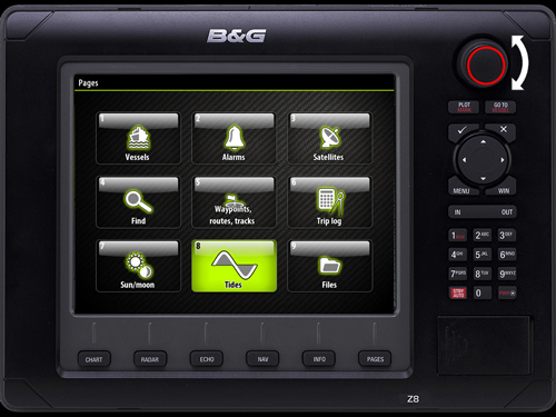
Excerpt from the course
Expand Excerpt from the courseThis GPS interactive animation will show you that you can easily view the tide for your area.
Click on the image then follow the red square touch points to run the animation. Module 7 has 20 such animations to help you get into the workings and really understand such a device. By the time you complete this Module alone, you'll have full confidence in operating a GPS chart plotter with multiple sensors networked in.
Trusted by the world's leading sailing companies
From our students
4.9 out of 5 average across 74,583 student course ratings.
-
"I liked that there wasn’t pressure to rush. I could actually understand what I knew and what I still needed to work on."
Jamie, first-time boater
-
"By the time we chartered, I felt prepared instead of just approved. That made all the difference."
Alex, preparing for bareboat charter
-
"NauticEd helped me see boating as a skill I could build, not something I had to pass or fail."
Morgan, new boat owner