


- Home
- About Us
- Sailing Courses
- Powerboat Courses
- SLC - International License
- Yacht Vacations
- Find an On-Water Instructor
- Practical Courses
- Fighting Childhood Cancer
- Free Courses Signup
- Student Benefits
- Gift a Sailing Course
- Sailing Opportunities
- Sailing Licenses and Certifications
- About the Sailing Certifications
- Sailing Blog & Helpful Articles
- NauticEd Podcast Series
- Yacht Charter Resources
- School Signup
- Instructor Signup
- Affiliate Signup
- Boat Sharing Software
- Sailing Industry Services
- Support & Contact
- Newsroom
- Privacy Policy
Introduction to Celestial Navigation | Online Course

From Sun to Sextant: Celestial Navigation Techniques
Embark on a celestial journey with our Introduction to Celestial Navigation online course, where you'll uncover the simplest and most effective methods for celestial navigation. From learning to take an actual noon shot to determining your position using celestial bodies, this course offers practical applications for modern-day sailors.
Designed for beginners, this introductory course demystifies celestial navigation, breaking down complex concepts into easily digestible lessons. You'll gain a solid understanding of celestial navigation tools, learn to take sights with a sextant, and make necessary adjustments for accurate readings.
Whether you're a novice sailor intrigued by celestial navigation or a seasoned mariner looking to expand your skills, this course is essential for anyone seeking to learn traditional celestial techniques.
Estimated Time: 5 hours
Price: $39
Enroll in the Introduction to Celestial Navigation online course and discover the best and simplest way to learn about celestial navigation. You'll even be able to do an actual noon shot and determine your position.
This introductory online course breaks down celestial navigation into its simplest concepts and practical applications for modern-day sailors. From understanding celestial navigation tools and techniques to determining your position using the sun and stars, this online course will introduce you to the skills and knowledge necessary to navigate using traditional celestial navigation methods.
Whether you are intrigued by celestial navigation or looking to expand your sailing knowledge, this course is a must for anyone looking to become a confident navigator using traditional celestial navigation techniques. Enroll now and take the first step towards mastering the art of celestial navigation.
This Introductory Celestial Navigation Course will:
- Give you an understanding of spherical geometry
- Introduce you to the sextant
- Show you how to make adjustments
- How to take a sight
- Explain the relevance and importance of the noon sight
- Teach adjustments for your local precise time
- Lead you through the Almanac Publications and
- Finally, you'll be doing the latitude and longitude calculation of a real sighting. The Charts and how to use navigation tools
We guarantee both your satisfaction AND Lifetime access to any sailing course you buy from us
More about this Celestial Navigation Sailing Online Course
- Learn Celestial Navigation concepts and applications for modern-day sailors.
- View an excerpt from this Introductory Celestial Navigation Course
- A simple introduction to Celestial Navigation
- This Sailing Course takes approximately 5 hours of total time to complete
- Take as long as you need to complete
- Return as many times as you like to review
- Take the online test as many times as you like
- Adds the Celestial Navigation Endorsement to your Sailing Certificate
This is an ONLINE course and tests viewable in your browser window.
Today's Investment: $39
Not convinced yet that online sailing courses are cool? Visit our fully interactive and completely free Basic Sail Trim Sailing Course. You'll see why online e-learning is SO MUCH BETTER than a boring old Book.
There is a yearning to understand humankind's first navigational abilities. Do you feel it? How could these people have done what they did without geosynchronous satellites in the sky broadcasting precise electronic signals? Were they smarter than us? The answer lies in that they did what they had to do to survive.
Nowadays, we simply turn on our GPS and read out the exact position within 3 meters. So why Celestial Navigation then? Perhaps you're a purist, an engineer, or a mathematician, or perhaps you just want to satisfy your curiosity. At the very least you can always justify your yearning by the desire for a backup system.
And now, with NauticEd you can satisfy that yearning for just $39. This Introductory Celestial Navigation Course will take you about 5 hours to complete. Upon completion, you'll receive a NauticEd Certification of Celestial Navigation Proficiency and you'll be able to take a noon sight of the sun and determine your position on the earth in both latitude and longitude. The noon sight is one of the simpler methods and so no matter what background you have you will dispel any intimidation with Celestial Navigation from this moment on. As with all NauticEd courses, you can return to brush up on your coursework as many times as you desire for life for FREE.
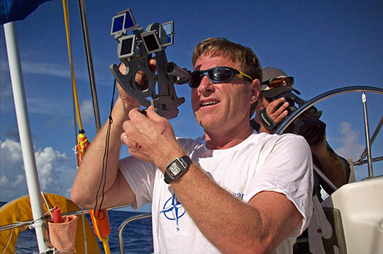
Please enjoy Captain Ed Mapes' Introductory Celestial Navigation Clinic. If you still have questions about NauticEd, the courses, and/or the sailing certifications, contact us via email or phone we're happy to help. Otherwise, register for the Introductory Celestial Navigation Course now!

By Ed Mapes
USCG Captain Master Mariner
Comments from Students like you
Learning how to use a sextant for celestial navigation has been very important to me as a USCG Captain and an engineer for a long time. Every tutorial I found online was confusing and frustrating, and my sextant sat in the closet for years. When I found NauticEd's Celestial Navigation class, I gave it a shot. The complex material is presented in a very straightforward, easy-to-understand manner. The subject matter is broken down into logical sections, which you are quizzed on before you proceed to the next, more complex material, one that is dependent on successfully completing the previous lesson. The course takes you through the steps of calibrating your sextant, taking a sight, making the correction calculations, timekeeping, and looking up the pertinent data in the reference publications. Then you get to calculate a mock noon sun sight from scratch! You don't actually need a sextant to take the class, but it helps. I had some questions about the sight calculations, and NauticEd got right back to me. You can't ask for better than that from an online class you can take from home at your leisure. Thanks NauticEd! I'm off to the boat to take a noon sight.
Captain Chris Larsen
USCG Master 100 Ton
San Francisco, CA
View Introductory Celestial Navigation Course excerpt
Student Reviews
Bern E.
2026, 06 May. 03:15
Nice intro course to celestial navigation. Provided a good perspective on how to use the sextant and its components and taking readings and why.
Terry R.
2026, 22 Apr. 04:09
It was a good introduction
Rene N.
2024, 24 May. 07:29
Good intro to celestial navigation.
Michael P.
2024, 14 Mar. 12:48
Concise
Yves D.
2023, 29 Oct. 02:37
Excellent introduction with nice drawing to explain the trigonometry
Gisle H.
2023, 19 Aug. 22:12
Good to know for ocean passages - if you bring along a sextant :-)
Showing last 6 reviews.
List Price: $39.00
Excerpt from the course
Expand Excerpt from the courseThe Introductory Celestial Navigation Clinic is presented in eight Modules:
- The Earth
- Glossary of Terms
- The Marine Sextant
- Sextant Adjustments
- Taking a Sextant Sight
- Time Keeping for Celestial Navigation
- Important Publications
- Exercise: The Noon Sight
The following are excerpts from the Clinic
The Earth
The Earth rotates around the sun once every year, but it also spins and makes a revolution around its own axis every 24 hours. When the Earth's circumference is divided into 24 equal sections, each represents one hour of the day's time and occupies 15 degrees of arc.
Figure 1 illustrates that each 15-degree segment is represented on a globe or chart by lines extending between the poles; these lines of longitude are called meridians. Meridians are widest at the equator and become progressively closer together toward the poles. It is important to understand that lines of meridian are not equidistant at different parts of the globe.
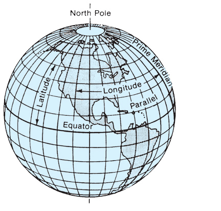
Figure 1: Lines of longitude extend between the poles, and are called Meridians of longitude.
Module 2
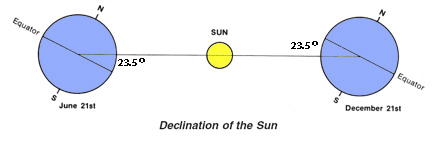
The following illustrates the slight complexity when measuring angles in a 3-D spherical geometry. Here GP is the point where the sun would be directly overhead. However, our vessel is east and north of GP. Thus the angle Hs that we would measure bears a complex relationship with the latitude and declination. Remember sine's and cosine's from geometry?
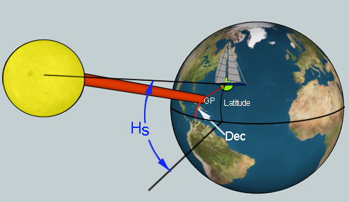
The zenith of our position is a point directly north (or south) of the GP. This helps us with the geometry a little because if we could project ourselves around the globe on the same latitude to the longitude of the GP then things would be a little easier. This is a partial secret of Celestial navigation.
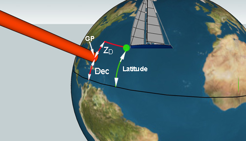
The following shows why it is much less complex to take a noon shot of the sun.
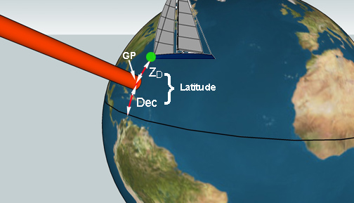
When the vessel is on the same longitude as the Sun's GP, the sun is at its highest point in the sky (for us at the position we are at - at that exact time). And if this occurred at the center of a time zone, then the time would be noon. In this clinic later we'll show how to account for not being exactly at the center of the time zone.
...
Thanks for viewing the excerpts - we're pretty sure you can extrapolate this information into knowing you'll have a full understanding of the theory behind and how to do a noon solar sight to determine your Latitude and Longitude position.
Sincerely,
The NauticEd Faculty.
Other sailing courses that you might enjoy
Weather
Catamaran Sailing Confidence
Trusted by the world's leading sailing companies
From our students
4.9 out of 5 average across 74,578 student course ratings.
-
"I liked that there wasn’t pressure to rush. I could actually understand what I knew and what I still needed to work on."
Jamie, first-time boater
-
"By the time we chartered, I felt prepared instead of just approved. That made all the difference."
Alex, preparing for bareboat charter
-
"NauticEd helped me see boating as a skill I could build, not something I had to pass or fail."
Morgan, new boat owner