James Cook Observation of Solar Transit of Mercury
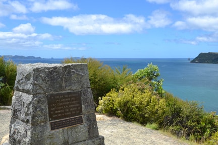
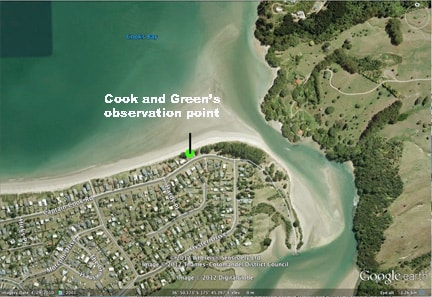
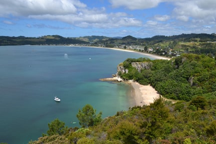
This weekend I visited a very special and historically significant celestial navigation place. It’s called Mercury Bay and it’s in the Coromandel Peninsula in New Zealand. Cooks beach lies on the edge of Mercury bay and is thus named after lt. James Cook, the famous world explorer of the 1700’s. Cook visited Mercury Bay in his ship the Endeavour between November 5th and 15th, 1769. Cook also named the bay thus because this is the place where he and his astronomer Charles Green set up to watch the solar transit of Mercury on November 9th. So why would he do this? What’s the big deal?
The Royal Astronomical Society knew of the coming solar transits of Mercury and Venus in 1769. With funding from the King, they sent out many people to observe these celestial events in different parts of the globe. The observations would help in determining much about distances in our solar system. Cook’s first stop was to be Tahiti to observe the Venus transit, then after that he had been directed further south to find a great southern continent that was assumed to exist. In October 1769 he came upon New Zealand whereby he waited until November 9th to observe the Mercury transit.
As a side effect of these observations, some accurate longitude information could be determined from the observation posts. In those days, calculating longitude accurately in remote locations was almost impossible because you needed to know the time in Greenwich, the 0 degree longitude datum. But with out a time piece that would stay accurate on a rolling sea how could you know the time?
In theory here’s how the longitude determination simply works. Let’s just say that the event would take place at Midnight Greenwich time. But the Endeavour’s crew observed the event to take place at noon local time. That would mean that Cook was 12 hours away from Greenwich. Since the planet rotates in 24 hours and there is 360 degrees in a circle, 15 degrees represents 1 hour.
As a quick aside explanation of that. Let’s say you know the time in Greenwich is 1 pm yet the local time where you are is 12 noon. You are 1 hour away from Greenwich and thus 15 degrees west. This is how time relates to longitude.
Thus, in the example, Cook would have been 12 x 15 = 180 degrees away from Greenwich. Cook would have gained the local time by observing the apex of the sun to obtain the local accurate noon time. Plugging in the real numbers then, the Royal Astronomical Society of England was later to determine the longitude of a place about 300 yards west of the river at the east end of Cooks beach by comparing the time of the occurrence in Greenwich and the time at Cooks beach (plus a few other factors like diameter of the earth etc). The observation place on Cooks beach is 174 deg 45 min west. Cook went on through March 1770 to draw a very accurate map of New Zealand charting most of the coastline almost exactly. Also as a result the Royal Astronomical Society was able to determine a measurement of the Earth to the Sun. Their results differ only 1/8th of 1 percent from today’s measurements. All pretty impressive I say and thus making Mercury Bay a worthy place of historical significance.
Several years later Cook returned to New Zealand carrying the latest technology, a chronometer. Commonly known today as a watch. The watch invention was very significant because it was immune to the rolling seas. Knowing the exact longitude, Cook was then able to reset his watch to the correct time upon arrival in New Zealand noting the daily offset in seconds the watch would have suffered on the trip between England and New Zealand. He then went on to use his watch to calculate and reposition accurately all of the Pacific islands he discovered and revisited from his previous visit, again taking into account the time offset.
The NauticEd celestial navigation course written by Captain Ed Mapes is a great start to understanding the technical details of calculating longitude using a noon shot of the sun. Take the NauticEd celestial navigation sailing course today.
One of Cook’s favorite Pacific islands besides New Zealand was Tahiti. Tropical warm waters, an abundance of fresh fruit and friendly people was one of his reasons. Speaking of Tahiti, if you obtain the NauticEd sailing certification of Bareboat Charter Master rank before June this year, you’re invited to get on a jet liner fly at 500 miles per hour and captain your own luxury modern sailboat using a wonderful GPS in our sailing flotilla starting June 16 this year. Can you imagine giving that invitation to Cook? Count yourself lucky, but only if you take advantage of this offer.
Visit our Sailing flotilla opportunity in Tahiti
I guess we’ll have to visit the place where he observed the Venus Transit – come join us.
What the heck? Take the plunge and a jolly good worthy life challenge – become a NauticEd Bareboat Charter Master and Yacht Master now!
- RYA Day Skipper with NauticEd - April 1, 2024
- NauticEd uses the SailTies GPS Tracking App - March 29, 2024
- Sea of Cortez Flotilla – February 2025 - March 8, 2024


