Simplistic Explanation of Latitude and Longitude Determination
The posting here is not a course in celestial navigation by any means. However it’s meant to simplify a few principles for you so that you’ll at least have some sort of celestial orientation. And… perhaps it’ll inspire you to learn the aging art.
This was written by Grant Headifen, Educational Director of NauticEd. NauticEd provides online sailing courses and Sailing Certifications accepted by charter companies worldwide.
Latitude: In the northern hemisphere, finding latitude is simple using one of the greatest gifts to human kind – The North Star. What ever angle the northern star is at from the horizon, that’s your latitude.
Imagine you’re an ant sitting on the top of an apple looking at a spot directly above you on the ceiling then the spot is 90 degrees from the surface you’re standing on. If you’re standing half way around the apple then you’d barely see the spot but it would be horizontal to the surface you’re standing on and so the spot would be at zero degrees. And if you were ¼ of the way down the apple then the spot would be at 45 degrees etc. ie the northern star is the spot on the ceiling to us.
You can also find latitude using other celestial sightings but they involve table lookups and are slightly more complicated. Not meant for this post and also note that there are a few more complicated variables not taken into account during this simplistic explanation like the height of your eyeballs above the earths surface etc etc. But at least you’ve now got the principle.
Longitude: Now this is a fun one and in an incredibly easy principle. But years ago (early 1700’s) while the principle was easy then the execution was difficult. Read on to see why.
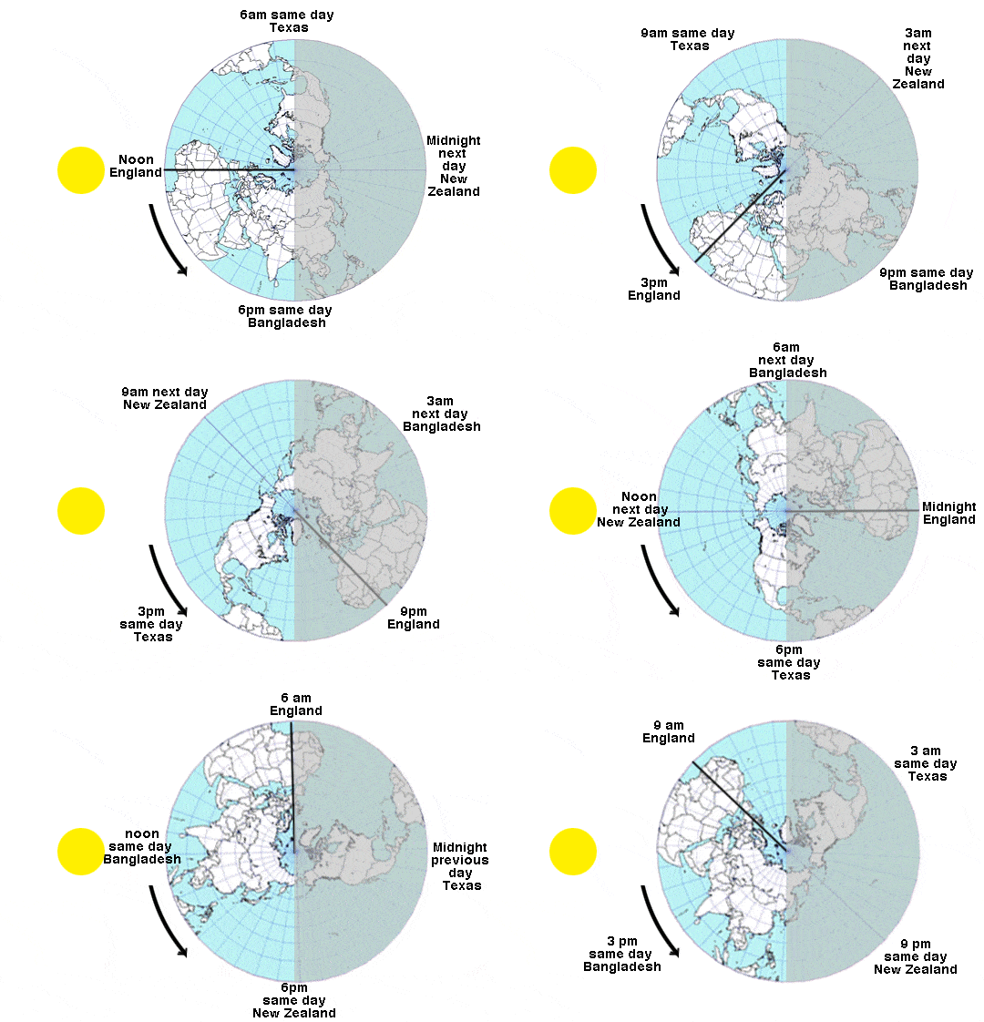
The earth rotates through 360 degrees in 24 hours. That’s 15 degrees per hour. By convention, when the sun is at it’s highest point in Greenwich, it is noon in Greenwich. That means that at a place that is 15 degrees to the West of Greenwich the sun will be at it’s highest point one hour later. Six hours after Greenwich the sun will be at it’s highest point somewhere in over the USA and 12 hours later the sun will be at it’s highest point in New Zealand.
So if we know the time in Greenwich and sun just reached its highest point where we are then we can calculate our longitude.
Lets do a few examples. If it is 6 pm in Greenwich and the sun just peaked overhead here, then I am 6 x15 degrees to the west of Greenwich which is 90 degrees West which is right near St Louis Mo.
If the sun peaked overhead in Los Angeles what time would it be in London.?Well LA is 118.15 degrees West (from Google earth). Divide that by 15 degrees per hour and we get 7 hrs 53 minutes. Now since the times zones are created in bands this would round up to 8 hours. Thus it would be 8pm in London.
You’re sailing in the Greek islands in the Mediterranean and a little bird just told you your latitude is 34 deg 54 minutes north but failed to tell you the longitude. Fortunately you have your handy sextant and just as you take a shot, the sun just reached its apex overhead. You look at your watch and the local time is 12:10:48 pm. Where are you?
Since you’re in time zone B you are 2 hours ahead of Greenwich. Thus the time in Greenwich is 10:10:48 am. And since the sun peaked just now (=noon) then you are 12:00:00 minus 10:10:48 = 1 hour 49 minutes and 12 seconds from Greenwich. Putting this into decimal time this is 1.82 hours. Multiply this by 15 degrees per hour and we have 27.3 degrees East or 27 degrees, 18 minutes East.
You’re in the harbor north of the town of Kos on the Island of Kos.
That was incredibly easy, so why all the hoopla back in the 1700’s? The King of England even offered up a ₤10,000 reward to anyone who could solve the issue of Longitude. The above math was well known but the issue was telling the time. No one could accurately keep time at sea. After 27 years of work on the project, John Harrison, finally invented the Chronometer more commonly known as the watch. The watch was not susceptible to the sudden crashes of waves at sea and thus kept proper time.
James Cook on his second trip around the world in 1772 sailing on Rendezvous, took Harrison’s watch with initially much skepticism. Stating that he’d give it a try. After six months at sea, Cook stated that the Chronometer would almost certainly become the way of the future for Navigators. Cook then went on to reposition many of the Islands in the Pacific including Tahiti, his favorite island. His map of New Zealand astounds people even today with its accuracy.
Again there were a few simplistic assumptions taken in that explanation. But now, at least you understand the principle of longitude determination from a noon shot of the sun. You can also determine your latitude from a noon shot of the sun as well using tables and a bit of math. Again beyond this posting.
If you’d like to delve deeper into these topics, NauticEd provides online sailing lessons and an Introductory Celestial Navigation Sailing Course, or maybe you’re just happy with your handy boring ol GPS.
- RYA Day Skipper with NauticEd - April 1, 2024
- NauticEd uses the SailTies GPS Tracking App - March 29, 2024
- Sea of Cortez Flotilla – February 2025 - March 8, 2024


