Sailing in Tahiti: Navigation Tips
June 2012: This last week, the NauticEd crew headed out on our annual Bareboat Charter Master Graduation Sailing Trip. This year we chartered catamarans from Dream Yacht Charters in Raiatea, about 200 km North West from the main island of Tahiti in French Polynesia. To get there you need to fly to Papetee on the island of Tahiti then take a puddle jumper for about 45 minutes to Raiatea. The Dream Yacht Charter Base is about 5 minutes from the Raiatea Airport but we stayed our first day and overnight at the Hawaiki Nui Hotel another 5 minutes away. I highly recommended the Hawaiki Nui on trip advisor – the huts were awesome and the food was great as with the staff. We did a night scuba dive on a wreck just off the dock at the Hawaiki Nui in about 60ft of water. It was a pretty cool dive and incredibly convenient – the dive shop is right at the hotel. By the time we finished the dive, the hotel was in full swing of a very lively and traditional Tahiti Dance show.

Hawaiki Nui Hotel – Raiatea
Jerome from Dream Yacht Charters showed up earlier that day and gave us an excellent chart briefing of the sailing area in preparation for us to pick up our catamarans the next day. Jerome was incredibly friendly and gave us a PDF of the chart briefing which we were able to put onto our iPads.
Saturday morning we split up into 2 groups – 1 to get squared away with the boats and 2 to attain provisions. Then by about noonish we were ready and we all set off.
Sailing in the area was very different than typical Caribbean sailing. First off, the place is sooooo beautiful that I ended up taking over 1000 photos with my Nikon D3100. Each island is surrounded by an outer ring reef and so the sailing that you do is either inside the lagoon or in serious open water between islands.

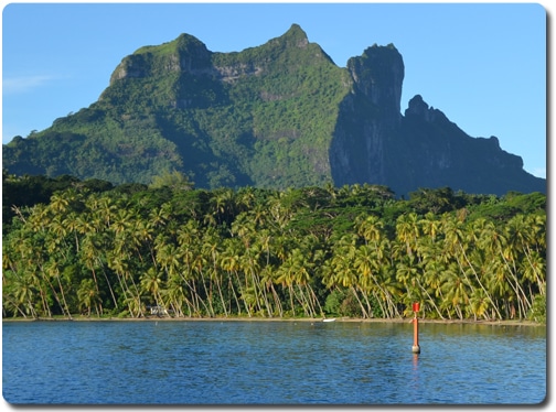
Bora Bora Lagoon
In the photo above you can safely sail in the blue water shown inside the lagoon. Although as you will discover safely is a relative term.

Sailing in the Lagoons
Above, one of the Dream Yachts Catana Catamarans in our NauticEd flotilla fleet.
Below, waves crashing on the outer reef. You’ve got to enter the lagoon only through the marked passages.

Waves on the reef at Bora Bora
Sailing inside the lagoons present a challenge – it’s not necessarily a hard challenge but certainly an awareness challenge as shown by the following photo which we snapped late one afternoon. The powerboat is pulling on a halyard to heel the sailboat over whilst the sailboat is trying to kedge out off the reef with the anchor and windlass. NOT GOOD.

On the Reef
In this photo below you can see extreme shallow water right next to the darker deep blue water.The photo a very typical scene – a well marked reef/shallow area next to an indescribably beautiful turquoise color with a deep rich dark blue in the foreground. The turquoise represents shallow water while the dark blue runs deep. You can notice a distinctive transition line between the colors. This is because the depth changes almost instantaneously. IE you get no warning from your depth meter. The front of the boat can be in 6 feet of water whilst the aft can be in 50 ft.

Turquoise and dark blue water
This photo below was a depth transition from 20 ft of water to 3 ft.

Depth transition highly visible by color change
Navigation markers however are reasonably abundant and so the navigation sailing lesson begins here.

Green Navigation Marker – Green to Sea
The rule to follow in French Polynesia when sailing around the island is to alway keep the green triangular navigation markers to the seaward side of the vessel and keep the red square markers to the island side of the vessel. For example if you are sailing so that the island is on your starboard then you keep red markers on starboard and green on port. If the island is on port then keep red to port and green to starboard. This rule will keep you in the navigable waterways.

Keep red to the island side
An exception happens when you approach an entrance or exit channel. These are marked by channel red and green markers and exhibit no difference to the island waterway markers. The Pacific (except Japan) use the IALA-A system of markers and so when entering a channel you must keep red on your port and green on starboard. IE it’s NOT red right returning. You must not confuse the green and red entrance/exit channel markers with the island waterway red and green markers. (In the USA intercoastal read and green markers have a yellow square on the marker to separate them from the red and green channel markers. Most other places in the world don’t do this).

Entrance channel to Bora Bora
When entering a channel there is usually a set of transit markers with a compass heading marked on the chart. This entrance into the Bora Bora lagoon is marked as 112 deg. So you just line up the transit markers on shore and follow the compas heading in. To exit you just take the reciprocal heading.
When the Transit Markers align you’re in the center of the entrance channel
In French Polynesia they also use the handy Cardinal marker system.

How to read Cardinal Marks
These also aided our navigation. This one below told us to stay west of this mark. You can see the shallow water on the other side of the mark.

West Cardinal Mark
But from a distance this one looked like an isolated danger mark because we could not see the 2 upward triangles especially with the huts in the background. This mistake got us into some shallow water and we had to turn back. Additionally this was not placed on the chart.

A cardinal mark but difficult to see its marking
As we sailed around in the lagoons we soon learned that a more than keen lookout was required to spot the marks and look for water color change. What was interesting was the Jerome from Dream Yachts completely discouraged us from using the GPS. He said he’d rather us rely on keeping our heads away from a screen and looking at the water and navigation marks. We took note and sailing the whole week with out a GPS. Even when returning from Bora Bora to Raiatea we used line of sight 3 position fixes via compass to plot our position on the chart. It was good practice and we nailed the entrance. Cook would have been proud.

Crew Spotting the Navigation Marks
Another indication of shallow water is a bit more rudimentary but work none the less is that the locals have gone out and stuck sticks into the reef.

Sticks work as Navigation Markers
The shallow water is pretty obvious above in good light conditions but less obvious as the light changes and so the sticks below were a good help.

Sticks work as Navigation Markers
Dream Yachts provided us with some very good and accurate charts. So fortunately the whole navigation exercise was not that difficult but certainly we’ve tried to instill above:
- you really need to know the markers,
- know where you are at all times
- keep a constant watch out 100% of the time
- use the overhead light to identify shallow areas
- use other signs and indicators
We highly encourage you to get on down to Tahiti for an incredible sailing adventure overall we had a real blast and so did the kids that we took along.

Vivian, Alexandra and Evan Sailing in the Bora Bora Lagoon
A few highlights of the trip was a visit to the Anapaperles Pearl farm.

Pearl Farm Hut (complete with convenient rainbow)
Inside looked something quite different.

Inside the Pearl Hut
And right underneath we went for a 30 minute snorkel through the oyster nets where the oysters grow and produce the pearls.

Oyster Nets
Another highlight was one of the best snorkelling experiences I’ve ever done (and I’ve done a lot). We snorkelled between two Motos (Islands) where the current runs at about 1 knot in a depth of about 5 feet. The area is called the coral river and it is loaded with fish and coral heads. Here’s a short video with a fun end.
[vsw id=”0PRWpVjzeks” source=”youtube” width=”425″ height=”344″ autoplay=”no”]
Thanks to the Mai Kai Marina and Yacht Club in Bora Bora. They were incredibly hospitable. Filled us up with water and some very nice Mai Tai drinks and excellent food. We well worth while stop. They are on Bora Bora Island on the left just after you enter the main entrance into the Bora Bora Lagoon.

Mai Kai Marina and Yacht Club
The final coup de grace of the trip was to visit the place on Tahiti Island where Captain James Cook witnessed the transit of Venus across the sun in 1769. He’d been sent to the south pacific to witness the event and take time measurements so that the Royal Astrological Society could use the data to calculate the size of the solar system. Ironically this event reoccured the week prior to our visit to Tahiti.

Monument to Cooks Effort in Observing the Venus Transit in 1769
What next?
Take the NauticEd Coastal Navigation Course – it is definitely what is needed to instill the confidence to do a trip like this.
Contact us if you’re interested in sailing vacations in Tahiti or beyond – we can arrange the trip for you, give you some good advice on getting there and places not to miss.
- RYA Day Skipper with NauticEd - April 1, 2024
- NauticEd uses the SailTies GPS Tracking App - March 29, 2024
- Sea of Cortez Flotilla – February 2025 - March 8, 2024